

Collection: Osher Map Library Collection
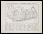
Name: New Map of Portland issued by Gosse, Newhall & Co., 68 Middle Str., cor. Exchange
Barcode:
Image Number:
Publisher:
Publishing Location:
Date/Date Range Produced: 1870 - 1874
Language:
Dimensions: 28 x 49 on sheet 46 x 60 cm
Brief Description: Shows distances from Portland to all railroad stations in Maine. Map key indicates horse railroads, ward lines, what areas of the city were burnt in the fire of 1866. Includes the locations of fire alarm boxes.
LC Call Number: G3734.P8 1874 G6
OCLC: 1017490402
Accession Number: OML-1874-59
Permanent URL: